We pulled out of Anacortes at 8:45 AM yesterday for a 9:30 appointment in Burlington to have a supply line toilet leak fixed under the EDGE warranty, which expires this week. Then we went to Costco for cheap gas and to look at smart phones, then back to the Anacortes PO to pick up forwarded mail (no new edition of The Mail Seekers; it was there in 2 days), then an hour’s drive south to our campground.
.
What the hell’s a smart phone, you ask? It’s a cell phone that has online and GPS capabilities, allowing you to check/send email, check weather forecasts, do google searches – pretty much anything you do online with a computer. Will I be (even) smarter when I get the phone, you ask? Oh yeah! Albert Einstein is rolling over in his grave at the very thought of it.
.
Actually, the main reason I’m getting it is to enable me to connect to the internet while traveling when cell phone service is available but wifi is not. The phone serves as a wifi hotspot when connected to a computer. When I’m at home I spend about 2 hours a day on the computer: email, banking, investments, taxes, travel and campground research, and now the blog. With the phone, I can take care of business while Trish is driving, and we’re not forced to stay in crowded, overpriced private campgrounds just because they have wifi. Very few public campgrounds are wifi equipped.
.
The weather was cruddy, raining when we pulled into camp but it’s supposed to improve by Thursday. We’re here for 4 nights. Today, Trish will be visiting a friend who lives nearby while I take care of online business at the library. The next couple days we’ll hike, play golf, sit by the campfire and mellow out. Life’s a bitch.
.
This park is on the west side of the island, bordering Admiralty Inlet (Puget Sound). It has a few trails, lots of ferns and slugs, and is heavily wooded. Some of the trees, firs and cedars mostly, are huge; one of the big cedars is 500 years old.
Tuesday, August 10, 2010


Saturday, August 7, 2010
Day 69. Anacortes, WA


We took the ferry back to Anacortes this morning, spending a couple days here visiting one of Trish's friends and getting some work done on the rigs.
.
Yesterday we hiked up Mt Young, one of the highest points on San Juan Island. The mountain is part of SJI National Historical Park - English Camp, and has great views of SJI and surrounding islands.
.
In the mid 1800s, SJI ownership was claimed by both the US and Great Britain, and both had military camps on the island. In 1859, a US farmer by the name of Cutlar shot a pig owned by Griffin, a Brit farmer. The pig had repeatedly raided Cutlar's potato patch, and Cutlar had warned Griffin about it. The event got both military camps riled up and became known as The Pig War, a long term conflict that lastest several years; the US President even got involved. Although there was much spear rattling, ultimately there was only one casualty: the pig.
.
The Brit camp outnumbered the Yank camp 5 to 1, plus the Brits had several warships in the area. No doubt, had it come to actual combat, the Yanks would have been toast.
.
Here's a link to the full story: http://www.outwestnewspaper.com/pigwars.html.
.
Had I been there, I would have suggested to Cutlar that he throw a barbecue with the pig as a main course, lots of potatoes on the side and a keg of beer, and that he invite Griffin and the staffs of both camps to attend. True, it could have turned into a brawl, but odds are, the party would have resulted in an amicable resolution of the conflict.
.
Had I been there, I would have suggested to Cutlar that he throw a barbecue with the pig as a main course, lots of potatoes on the side and a keg of beer, and that he invite Griffin and the staffs of both camps to attend. True, it could have turned into a brawl, but odds are, the party would have resulted in an amicable resolution of the conflict.
.
Last night, we had fresh Dungeness crab that Phil and a friend harvested the day prior. Excellent!
.
The pix were taken from the top of Mt Young; the smiling couple are Phil and Kirsten, our hosts.
The pix were taken from the top of Mt Young; the smiling couple are Phil and Kirsten, our hosts.
Friday, August 6, 2010
Day 68. San Juan Island, WA


Last night we attended a potluck along with our hosts, Phil and Kirsten, at Lime Kiln Point State Park on the west side of San Juan Island. Limestone was mined and fired there for 60 years, starting in 1860.
.
The pictured kiln, one of several, was rebuilt to give visitors a better feel for the lime producing process. The whitened area of rock in one of the pix is immediately below another, unrestored, kiln and is the result of the waste being removed from the kiln after the firing was completed. Ships pulled right up to shore near the kilns and the barrels of lime were loaded aboard and transported to various locations for making cement.
.
The west side of the island is a good area for seeing killer whales. There were a few whale watch boats out and I caught a glimpse of whale surfacing as I drove along the coastline. Once at the park, I got out the binoculars but didn't spot any more whales.
Wednesday, August 4, 2010
Day 66. San Juan Island, WA
.jpg)


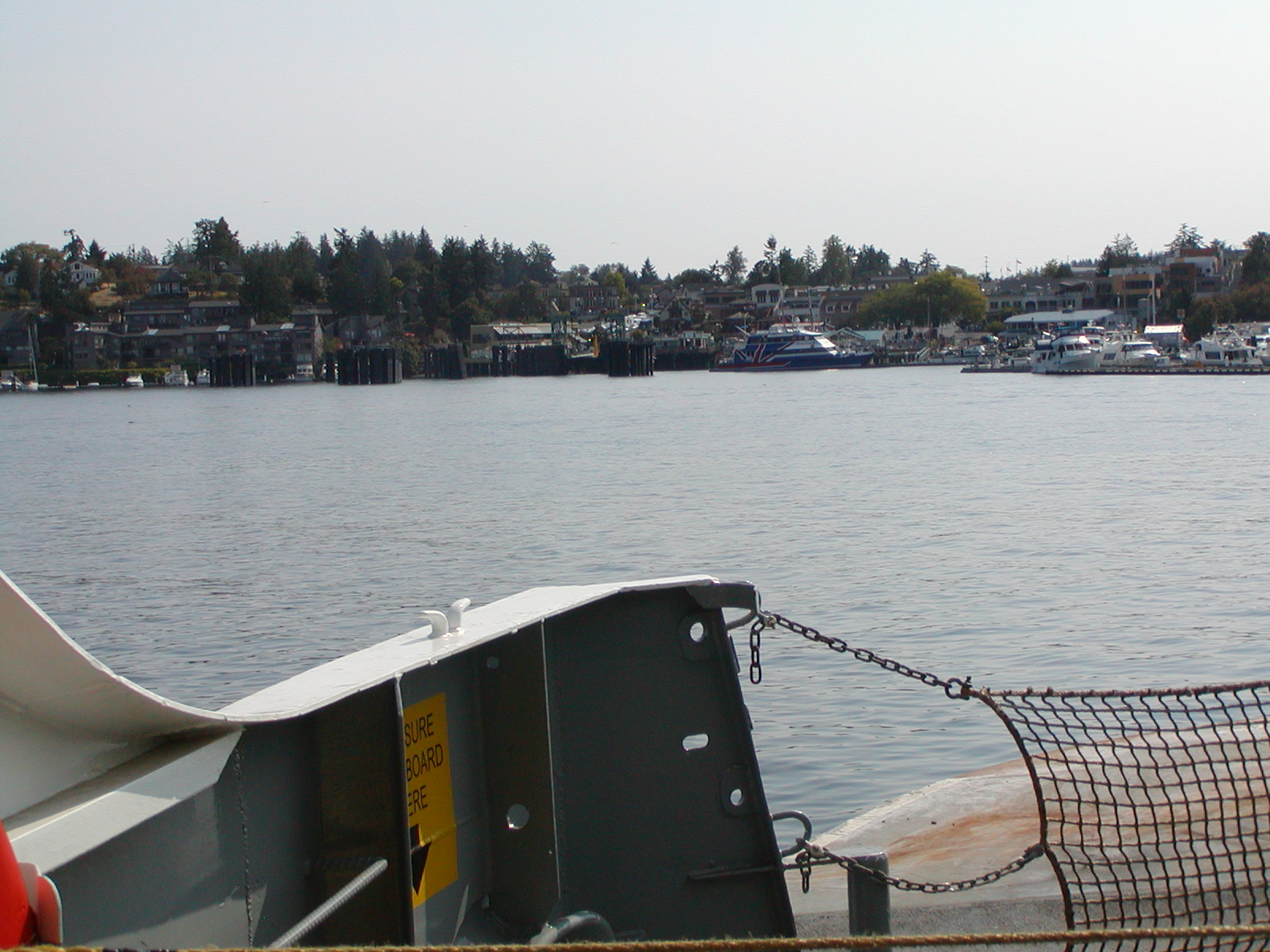

 We took one of the huge WA State ferries from Anacortes, WA to Friday Harbor, WA yesterday to visit friends on San Juan Island. It's spendy, taking both pickup and trailer on the ferry but it was worth it. Otherwise we'd have to pay to park the trailer at a mainland park for 4 days, and we wouldn't have our own bed, food, etc. We're parked in our friends' yard so no campground fees.
 .
Our hosts, Phil and Kirsten, fixed a fantastic meal of fresh razor clams last night. Phil's a retired commercial fisherman, did his thing in Cook Inlet and Bristol Bay in Alaska, still plays a mean game of tennis at 70. Kirsten owns/manages vacation rentals here on the island. They head south for several weeks each winter and visited us in LHC last season.
.
The San Juans are scenic and always a delight to visit, especially in summer. The ferry ride to San Juan Island takes an hour plus; along the way, you see many sailboats, yachts, freighters, you name it.
.
The top 2 pix are of a smaller ferry pulling into Lopez Island after we pulled out. The ferry we rode on, the Yakima, is the largest size in the system, I think. Middle pix are of, or from the Yakima; bottom pix is of the Anacortes ferry terminal.
Monday, August 2, 2010
Day 63. Trip miles: 10425. Lynden, WA
We’re baaaaack! It’s great to be in the Lower 48 again. Canada is fine and I don’t mind adding ‘eh’ to the end of every sentence, but the gas prices are terrible.
For the next 3 weeks we’ll be visiting friends in the San Juan Islands, Olympia, Shelton and Seattle. In late August we’ll head down to OR and visit friends and relatives there for another 3-4 weeks before heading back to AZ.
We’re at the KOA campground in Lynden and it’s a beautiful facility, family oriented, with lots of rug rats. Roughly 4/5 of the folks here are from BC. It’s a 3-day holiday for them (BC Day!).
Mostly, we avoid KOAs like the plague. They’re the antithesis of everything we enjoy about RVing which is lots of space, quiet, private, cheap, campfires allowed. Sometimes though, they’re the only game in town so here we are.
Yellowhead: the rest of the story. Pierre Bostonais was a blonde Frenchman who traded with the Iroquois and later helped survey the Yellowhead Highway route in the early 1800s.
Now tell me: where else would one get all these invaluable lessons in history – not to mention geography, biology, ornithology and grammar? Priceless!
For the next 3 weeks we’ll be visiting friends in the San Juan Islands, Olympia, Shelton and Seattle. In late August we’ll head down to OR and visit friends and relatives there for another 3-4 weeks before heading back to AZ.
We’re at the KOA campground in Lynden and it’s a beautiful facility, family oriented, with lots of rug rats. Roughly 4/5 of the folks here are from BC. It’s a 3-day holiday for them (BC Day!).
Mostly, we avoid KOAs like the plague. They’re the antithesis of everything we enjoy about RVing which is lots of space, quiet, private, cheap, campfires allowed. Sometimes though, they’re the only game in town so here we are.
Yellowhead: the rest of the story. Pierre Bostonais was a blonde Frenchman who traded with the Iroquois and later helped survey the Yellowhead Highway route in the early 1800s.
Now tell me: where else would one get all these invaluable lessons in history – not to mention geography, biology, ornithology and grammar? Priceless!
Day 62. Evening. Wildwood, BC

We were sorely tempted to hang a left off highway 97, aka the Cariboo Collector, take the side road to Horsefly, BC, and visit the Horseflyers, but we resisted and ended up here, a few miles north of Williams Lake. Wouldn't it be great to live in a town called Horsefly?
Canadians like to name their roads: Stewart Cassiar, Yellowhead, Cariboo Collector; we drove on all 3 today. I kinda like the naming thing; they all have numbers also. Gotta look up Yellowhead, was told it refers to some famous Kanuck that had blonde hair.
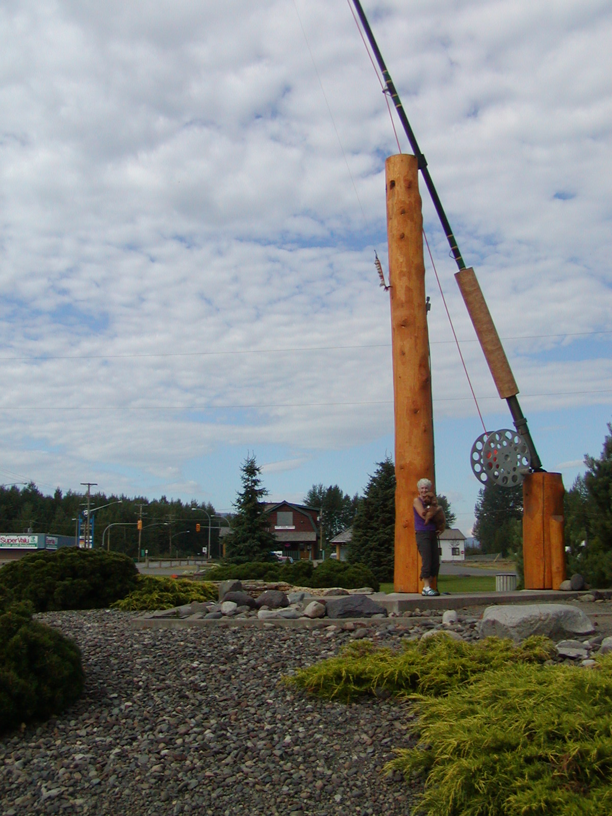
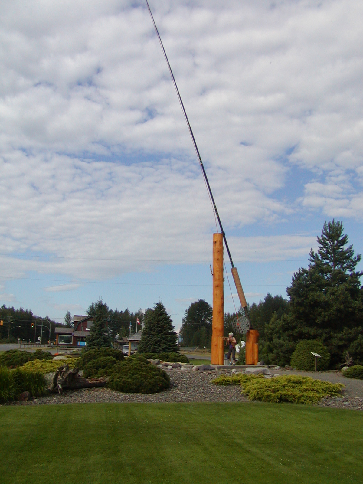
In our first hour of driving today we saw a black bear, a moose and a WL. For those who just tuned in or have short memories, WL stands for World’s Largest, and we’ve seen many fine WLs along the way. Today’s WL was a fly rod located in the town of Houston, BC. It weighs 800 pounds so usage is limited to a small number of really buff fishermen.
Most of today’s drive was through smoke. There are 350 wildfires burning in BC Province, not sure how many or how large are the ones near us. One of the locals said we’ll continue driving in smoke tomorrow for another 150 miles beyond Williams Lake. The sun has an orange tint due to the smoke, looks weird.
The trip odometer went back to zero today, which means we’ve gone over 10000 miles. I’ll provide the official mile count when we arrive at our first stateside campground and the end of the 3rd leg of our odyssey. No doubt y’all are on the edge of your seats waiting for that bit of totally useless trivia.
They charge extra ($3 a day) for wifi here at the Wildwood RV Park. I’m a cheapskate so didn’t pony up, don’t like being nickel-dimed to death. This is the only campground we’ve stayed in that charged extra. So, this post won’t hit the streets until tomorrow.
Sunday, August 1, 2010
Day 62. Morning. Smithers, BC
It wasn’t ugly after all, played well for a change and got several pars on the 18-hole par-3 course. The course and the campground are run by the same people; there’s also a restaurant and through July they offered free golf to anyone who ate there. We did eat there so our golf was free, a very good price.
There was a caravan of about 25 rigs due in here last night but they didn’t arrive. I suspect they were coming from the north and got stopped by the large fire that’s burning near the northern section of the Stewart Cassiar Highway. The SCH was closed for awhile and maybe still is. We drove through the area the same day the fire started, saw the smoke and a helicopter carrying water to the fire. We heard a rumor that the Alaska Highway was also closed. It was lucky timing for us to have missed all that.
In an earlier post, I mentioned being curious about the name Stewart. Here’s the poop. James Stewart (not the actor) worked for the Hudson’s Bay Company in the mid 1800’s. He and his boss, Robert Campbell, explored northern BC and Campbell was responsible for naming the Stewart River after Jimmy – and then the name spread to the town and the highway.
In another earlier post, I speculated that the loon may be Canada’s national bird. It is not. In fact, they have no national bird but seem to be in the process of selecting one. Citizens are currently offering suggestions on what the national bird should be, and the loon ranks number 3, behind the red tailed hawk and the Canada goose.
It’s 6:45 AM. We’ll be hitting the road in about an hour, destination Williams Lake.
There was a caravan of about 25 rigs due in here last night but they didn’t arrive. I suspect they were coming from the north and got stopped by the large fire that’s burning near the northern section of the Stewart Cassiar Highway. The SCH was closed for awhile and maybe still is. We drove through the area the same day the fire started, saw the smoke and a helicopter carrying water to the fire. We heard a rumor that the Alaska Highway was also closed. It was lucky timing for us to have missed all that.
In an earlier post, I mentioned being curious about the name Stewart. Here’s the poop. James Stewart (not the actor) worked for the Hudson’s Bay Company in the mid 1800’s. He and his boss, Robert Campbell, explored northern BC and Campbell was responsible for naming the Stewart River after Jimmy – and then the name spread to the town and the highway.
In another earlier post, I speculated that the loon may be Canada’s national bird. It is not. In fact, they have no national bird but seem to be in the process of selecting one. Citizens are currently offering suggestions on what the national bird should be, and the loon ranks number 3, behind the red tailed hawk and the Canada goose.
It’s 6:45 AM. We’ll be hitting the road in about an hour, destination Williams Lake.
Subscribe to:
Posts (Atom)